Related Posts Plugin for WordPress, Blogger...
Fourni par Blogger.

Smokies Roadways Closed Due to High Winds and Downed Trees - Park Advises Hikers to Stay Off Trails

Great Smoky Mountains National Park is experiencing high winds ahead of a cold front that is expected to move through the area later today. Newfound Gap Road (Hwy 441 from Gatlinburg, TN to Cherokee, NC), Little River Road from the Townsend Wye to the Sugarlands Visitor Center, Wears Gap and the Roaring Fork Motor Nature Trail are currently closed. Winds are expected to grow stronger this evening with gusts up to 45 mph across the higher elevations. The current road closures will remain in effect until the High Wind Warning has expired. At that time, crews will reassess conditions and begin clearing roads for reopening.

Hikers are advised to avoid hiking during this time period across the park, particularly in areas with standing dead trees. Park visitor centers and the Cades Cove Loop Road will remain open at this time. Visitors should exercise extreme caution when making travel plans.

For more information about temporary road closures, please visit the park website at www.nps.gov/grsm or follow SmokiesRoadsNPS on Twitter.


Jeff
HikingintheSmokys.com
RockyMountainHikingTrails.com
HikinginGlacier.com
TetonHikingTrails.com
Ramble On: A History of Hiking

Hazardous Weather Warning for Smokies Today

High winds and flash flooding are expected today across the Smoky Mountains. You may want to monitor the Smokies Twitter account for road closure updates if you plan to visit the park today: https://twitter.com/smokiesroadsnps Here's the forecast from the National Weather Service for today:
This Hazardous Weather Outlook is for portions of southwest North Carolina...east Tennessee and southwest Virginia.

.DAY ONE...Today and Tonight

Severe storms will be possible early Thursday morning into early Thursday afternoon ahead of a cold front with strong winds being the primary hazard. A brief weak isolated tornado or two will also be possible. Best chances for severe storms will be to the north and east of Knoxville during the morning and early afternoon hours.

Periods of locally heavy rainfall are possible Thursday morning and afternoon which may cause localized flooding, especially across the Smoky Mountains, southeast Tennessee, and southwest North Carolina.

Strong winds will continue across the higher elevations into the early afternoon with gusts as high as 45 mph possible.

Freeze temperatures along with patchy to widespread frost are expected late tonight.

.DAYS TWO THROUGH SEVEN...Friday through Wednesday

Freeze temperatures along with patchy to widespread frost will continue into Friday morning.


Jeff
HikingintheSmokys.com
RockyMountainHikingTrails.com
HikinginGlacier.com
TetonHikingTrails.com
Ramble On: A History of Hiking

Avoir ou Être ? Un choix dont dépend l'avenir de l'homme !

Salut à tous,

Du site philo.5 :  

   ¨  Différence entre avoir et être !
      Le choix entre avoir et être  en tant que notions contraires, ne frappe pas le sens commun. Avoir, semblerait-il, est une fonction normale de notre vie : pour pouvoir vivre, il faut avoir certaines choses. En outre, nous devons avoir certaines choses afin d'en tirer plaisir. Dans une culture dont le but suprême est d'avoir — et d'avoir de plus en plus — et où on peut dire d'un individu qu' « il vaut un million de dollars », comment peut-il y avoir une alternative entre avoir et être? Au contraire, il semblerait qu'avoir est l'essence même d'être ; et que celui qui n'a rien n'est rien.

  Origine des termes !
     « Avoir » est une expression faussement simple. Tout être a quelque chose : un corps [2], des vêtements, un toit... ou, pour l'homme et la femme modernes, une auto, un poste de télévision, une machine à laver, etc. Vivre sans rien avoir est pratiquement impossible. Pourquoi, alors, avoir serait-il un problème? Cependant, l'histoire linguistique d' « avoir » montre que le mot est bel et bien un problème. Ceux qui croient qu'avoir est l'une des catégories les plus naturelles de l'existence humaine seraient très surpris d'apprendre que de nombreux langages n'ont aucun mot correspondant à « avoir ».

 Concepts philosophiques d'être !
   L'étude du concept d'être se complique de surcroît par le fait qu'être a été l'objet de milliers d'ouvrages philosophiques et que la question « qu'est-ce que être? » a été l'une des plus importantes qu'ait posé la philosophie occidentale. Le concept d'être sera traité ici du point de vue anthropologique et psychologique, mais il est évident que l'étude philosophique n'est pas sans rapport avec les problèmes anthropologiques.

Avoir ou être l'autorité !
   Un autre exemple de la différence entre le mode avoir et le mode être est l'exercice de l'autorité. Le point essentiel s'exprime par la différence entre avoir de l'autorité et être une autorité. [...] le mot « autorité » représente un terme général qui a deux acceptions totalement différentes : l'autorité peut être « rationnelle » ou « irrationnelle ». L'autorité « rationnelle » est fondée sur la compétence et aide la personne qui s'appuie sur elle à se développer. L'autorité « irrationnelle » est fondée sur le pouvoir et sert à exploiter la personne qui lui est soumise.

Aimer !
   « Aimer » a aussi deux significations, selon que le mot est exprimé sur le mode avoir ou sur le mode être. Peut on avoir un amour? Si c'était possible, l'amour serait nécessairement un objet, une substance que l'on a, que l'on possède. En réalité, il n'existe pas d'objet qui s'appelle « amour ». L' « amour » est une abstraction, peut-être une déesse, ou un être étranger, mais personne n'a jamais vu cette déesse. En réalité, seul existe l'acte d'aimer. Aimer est une activité productive, qui suppose qu'on ait un penchant, qu'on connaisse, qu'on réagisse, qu'on affirme, qu'on prenne plaisir ; qu'il s'agisse d'une personne, d'un arbre, d'une peinture, d'une idée. Aimer signifie donner vie, accroître l'intensité de sa propre vie. C'est un processus qui renaît et s'accroît de lui-même.

    Quand l'amour est expérimenté selon le mode avoir, cela signifie qu'on limite, qu'on emprisonne, qu'on contrôle l'objet « aimé ». C'est étrangler, étouffer, asphyxier, ce n'est pas donner vie. Ce que les gens appellent amour est le plus souvent un mauvais usage du mot, en vue de cacher la réalité du fait qu'ils n'aiment pas¨...  ( Voir l'article au complet )

 http://www.philo5.com/Mes%20lectures/Fromm_AvoirOuEtre.htm?fbclid=IwAR3f0H80ldBRC79jNEgH5gDPAqSZ0XwRZLNxRvEhF_6YOXdX-ben83dVJNo

Pégé
 
Windows 7 / Windows 10 / Ubuntu 18.04 LTS / Linux Mint 19


Smokies Roadways Closed Due to High Winds and Downed Trees

Great Smoky Mountains National Park experienced high winds this morning with sustained winds of approximately 30 mph and gusts up to 50 mph across the Tennessee side of the mountains. Newfound Gap Road, Laurel Creek Road, Little River Road and Cades Cove Loop Road are all currently closed due to downed trees. Winds are expected to grow stronger this evening with a High Wind Warning in effect until 5:00 a.m. on Sunday morning. All roadways will remain closed until the warning has expired. At that time, crews will assess damage and begin clearing roads for reopening.

Hikers are advised to avoid hiking during this time period across the park, particularly in areas with standing dead trees. Park visitor centers, campgrounds, and picnic areas remain open at this time. Visitors should exercise extreme caution when making travel plans.

Please visit https://www.nps.gov/grsm/learn/photosmultimedia/webcams.htm to view images from webcams across the park including Newfound Gap. For the most up to date information about road closures, follow SmokiesRoadsNPS on Twitter.


Jeff
HikingintheSmokys.com
RockyMountainHikingTrails.com
HikinginGlacier.com
TetonHikingTrails.com
Ramble On: A History of Hiking

Fire Restrictions on Open Fires in the Backcountry Lifted at Big South Fork NRRA

Due to recent precipitation, Superintendent Niki Stephanie Nicholas announced the removal of restrictions on open fires within the backcountry of Big South Fork National River and Recreation Area. Drought conditions for the area prompted the campfire restrictions on September 20.

Fire management staff stress that weather conditions can change rapidly. Both visitors and residents are asked to stay informed of fire danger and conditions.

Use caution when building fires. They must be completely extinguished with water, and cold to the touch before leaving them unattended. Fire must be used in accordance with state, local and park regulations.


Jeff
HikingintheSmokys.com
RockyMountainHikingTrails.com
HikinginGlacier.com
TetonHikingTrails.com
Ramble On: A History of Hiking

Smokies Adopts New Regulation for E-Bike Use

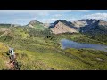
Great Smoky Mountains National Park officials have announced the adoption of a new regulation to allow the use of low-speed electric bikes (e-bikes) in the park at all locations where bicycles are currently allowed. Both Class 1 and Class 2 e-bikes, which can provide electronic assistance until the rider reaches a speed of 20 mph, are allowed under the new regulation.

Commentary: I have no problem with the park allowing e-bikes on all park roads. However, I think this is an absolutely horrible decision for them to allow these "low-speed motorcycles" on the hiking trails listed below. This is simply asking for trouble, and predict there will be many user conflicts in the years to come in this park, and the other national parks who have adopted this rule.

Park specific regulations, as described in the Superintendent’s Compendium or Code of Federal Regulations, Title 36, have been amended to record this change in Chapters 1. 4 and 4.3. Bicycles and e-bikes are allowed on any park road where motor vehicles are allowed; seasonally closed roads; and the Gatlinburg Trail between the Sugarlands Visitor Center and Gatlinburg (1.9 miles), the Oconaluftee River Trail between the Oconaluftee Visitor Center and the town of Cherokee (1.6 miles), Indian Creek Trail (2.9 miles), and Deep Creek Trail (1.4 miles).

E-bikes enable more people to enjoy a cycling experience in the park in a manner that is consistent with conventional bicycle use. Cyclists may only use the small electric motor to assist pedal propulsion. The motor may not be used to propel an e-bike without the rider also pedaling, except in locations open to public motor vehicle traffic. More people, especially those with physical limitations, will now have the opportunity to explore the park in a unique way.

For more information about biking inside the park, please visit the park’s website at https://www.nps.gov/grsm/planyourvisit/biking.htm.


Jeff
HikingintheSmokys.com
RockyMountainHikingTrails.com
HikinginGlacier.com
TetonHikingTrails.com
Ramble On: A History of Hiking

HikinginGlacier.com Adds 5 New Hikes to Online Trail Guide

This past September Kathy and I had the opportunity to visit Glacier National Park for almost three weeks. During our visit we hiked more than 140 miles throughout the Two Medicine, St. Mary Lake, Many Glacier, Logan Pass and Lake McDonald areas. Many of these hikes were on trails we've already covered on our website, HikinginGlacier.com, but felt they were important in order to provide improved photographs of the iconic scenery hikers will see along those routes. These photos have now been published throughout the site. In some cases we re-hiked trails to update the information previously published on the website. For example, we hiked up to Sperry Chalet to document the damage from the Sprague Fire of 2017 - not only the reconstruction of the historic Sperry Chalet dormitory, but also the damage to the forest you'll encounter as you proceed along the route to the chalet.

During our visit we were also able to hike a few new trails, which have just been added to the site. These are listed below.

All in all, our trip effectively resulted in a minor overhaul of the website. Roughly half the 68 hikes we cover on our site now have new and improved photos, as well updated information pertinent to hikers. Our online guide remains the most comprehensive resource for travelers as they plan their hiking itineraries for their visits to Glacier National Park. The hikes covered on our site are listed in alphabetical order, by difficulty level, by key trail feature, as well as by location within the park. We also provide lists of our top 10 hikes, and the best easy hikes to also help with all your planning needs.

Here are the new hikes we've added to the site:

Belly River Ranger Station - This hike visits the historic Belly River Ranger Station in the northeast sector of the park - just north of Many Glacier. The district contains several historic buildings, including the original ranger cabin constructed in 1912, making it one of the oldest continually manned ranger stations in Glacier National Park. The station also has the distinction of being the only ranger station in the park to be accessible only by trail. It's assumed that it was at least partially built by Joe Cosley, who was among the first six rangers to be hired by the new park. Cosley, a poacher, eventually resorted back to his hunting and trapping ways while working as a ranger. The description for this hike contains a few more details about this legendary figure from the early years of the park.

The Dragon's Tail - This is a great alternative if you're looking to avoid the extreme crowds at Hidden Lake Overlook. Although you'll start-off using the same trail, the "climbers route" to Mt. Reynolds and the Dragon's Tail splits off from the main trail after roughly a mile. Hikers will enjoy sweeping views of Hidden Lake and the surrounding mountains from the east and southeast side of the lake. I loved this hike so much that it now ranks 4th on my list of the top hikes in Glacier National Park.

Upper McDonald Creek Trail - This relaxing hike travels through a lush, old-growth forest more normally found along the Pacific Northwest Coast. Along this route you'll visit Sacred Dancing Cascade and McDonald Falls, and end with a spectacular view of Mount Cannon rising almost 5600 feet above the valley floor. This is a great alternative if you wish to avoid the crowds along the Trail of the Cedars.

Sun Point Nature Trail - This is another pleasant hike that offers outstanding views of St. Mary Lake. It also visits Baring Falls and St. Mary Falls.

S. Shore St. Mary Lake - After visiting St. Mary Falls and Virginia Falls the trail continues to a rock outcropping that overlooks St. Mary Lake from its southern shore. From this vantage point, roughly one hundred feet above the lake, you’ll enjoy a commanding view of the peninsula that juts out into the lake across from Sun Point, as well as the mountains rising above the north and northwest side of the lake.


Jeff
HikingintheSmokys.com
RockyMountainHikingTrails.com
HikinginGlacier.com
TetonHikingTrails.com
Ramble On: A History of Hiking

Uluru, site sacré en terre aborigène !

Salut à tous,

 Du site France Culture : L'origine des mondes culturels | Uluru ou Ayers Rock est un imposant rocher situé au centre de l’Australie, dans le Territoire du Nord. Lieu incontournable du tourisme sur le continent, c’est avant tout un site sacré pour les peuples aborigènes qui vivent dans cette partie du désert australien. 

¨ C’est un symbole de l'Australie, une de ses représentations dans le monde entier : le rocher Uluru ou Ayers Rock dans le Territoire du Nord.
   Les touristes sont environ 300 000 à s’y presser chaque année, certain.es n’hésitant pas à escalader le mastodonte de près de 350 mètres de haut. Mais pour les peuples aborigènes présents dans cette région, ce site est avant tout sacré, témoin de leur histoire. A partir du 26 octobre prochain, l’ascension du rocher sera donc interdite. Les autorités ont dénombré une trentaine de morts depuis les années 1950 lors de l’escalade du mont, réputée dangereuse, en raison de la difficulté physique de cette montée et de la chaleur qui y règne.

Un site découvert il y a moins de deux siècles par les colons…
    "Tout ce que l’on peut dire au sujet d’Uluru ne remplacera jamais ce que vous y découvrirez par vous-même." Ainsi est décrit dans le guide touristique du Petit Futé le rocher majestueux qui s’élève au milieu du désert australien. Le monolithe en grès de 348 mètres de haut et de 9,4 kilomètres de circonférence est entouré d’histoires sacrées. Un côté mystique renforcé par sa couleur rouge orange qui change en fonction du soleil, tournant au violet à la pénombre.

…Mais sacré depuis des milliers d’années pour certains peuples aborigènes !
   Difficile donc d’évoquer Uluru comme un symbole de l’histoire aborigène. _"Le terme ‘symbole’ réduit la réalité et le pouvoir de ces endroits sacrés et de leur histoire, à la fois humaine et non humaine"pour Barbara Glowczewski. Et il est difficile de qualifier l’histoire aborigène d’unique. Car en quelques 80 000 ans de présence en Australie ("d’après des découvertes archéologiques très récentes"_ selon Barbara Glowczewski), il existe autant d’histoires que de peuples sur le continent (et il y a plus de 300 langues différentes).

 Le paysage comme patrimoine culturel !
   Dans leur livre Les Aborigènes d’Australie, Stephen Muecke (professeur émérite d’ethnographie à l’Université New South Wales de Sydney) et Adam Shoemaker (vice-chancelier de South Cross University, spécialiste de la littérature et culture aborigène) racontent ce Dreaming (qui a aussi été appelé Dream Time) qui entoure Uluru.

   "Uluru est l’un des sites sacrés les plus importants pour les Aborigènes de la région car il fut le théâtre d’une terrible bataille entre les Kuniya (les Pythons des Rochers) et les Liru (les Serpents venimeux) qui marqua la fin du temps du rêve et inaugure l’âge des hommes."...
( Voir l'article au complet )

https://www.franceculture.fr/religion-et-spiritualite/uluru-site-sacre-en-terre-aborigene

Pégé

Windows 7 / Windows 10 / Ubuntu 18.04 LTS / Linux Mint 19


Roadwork Near Cataloochee Area Postponed

Great Smoky Mountains National Park officials have announced that the expected closure of the main access road into Cataloochee has been postponed. The county road just outside the park, Cove Creek Road, was expected to be closed November 1 through February 29 for a road slide repair by the North Carolina Department of Transportation. The roadwork has been postponed and the Cataloochee area will remain open and accessible throughout the fall and early winter, aside from weather-related closures. For more information about the roadwork schedule, please contact the North Carolina Department of Transportation.

For more information about park road closures, please follow SmokiesRoadsNPS on twitter or visit the park website at www.nps.gov/grsm.


Jeff
HikingintheSmokys.com
RockyMountainHikingTrails.com
HikinginGlacier.com
TetonHikingTrails.com
Ramble On: A History of Hiking

Science at Sugarlands / Mount LeConte Shelter

Join Great Smoky Mountains National Park for Science at Sugarlands tomorrow from 1:00-3:00 p.m. for "Lichens of the Smokies, Revealed" with James Lendemer from the New York Botanical Garden. All visitors are welcome to join the park at the Sugarlands Visitor Center Training Room, near the Gatlinburg entrance to the park.

Also, backpackers, and even day hikers, may want to note that the Mount LeConte Shelter has been closed due to aggressive bear activity.


Jeff
HikingintheSmokys.com
RockyMountainHikingTrails.com
HikinginGlacier.com
TetonHikingTrails.com
Ramble On: A History of Hiking

Parent noir, enfant blanc ou notre trouble vision du métissage !

 Salut à tous,

Du site Slate.fr :L'effet provoqué par ce duo souligne la prégnance des questions raciales dans notre société.  

¨  «Mon fils, il est tout blanc. En plus, il a les cheveux raides. Je trouve que ça ne se voit pas du tout qu'il est métis, à part son nez: il a un petit nez de Black, mais uniquement si on y prête attention, expose Jessica, 32 ans, cheffe de projet dans l'industrie pharmaceutique. Mes nièces étaient des enfants blanches quand elles sont nées. Elles avaient foncé au bout d'un mois. Mais lui, les mois passent et j'ai compris assez vite qu'il allait rester blanc» –et qu'il n'arborerait pas les couleurs martiniquaises de son grand-père maternel, mais aurait une carnation plus proche de celle de son père, d'origine irlandaise, sans l'inconvénient de rougir autant au soleil.

Identité épidermique !

   Bien sûr, la mélancolie que peut susciter cette disparité physionomique entre parent et enfant traduit une envie familiale plutôt répandue: celle que l'enfant ait des traits similaires à ceux de ses ascendants.

  Pour Jessica, qui supposait lorsqu'elle était enceinte que son enfant serait «plus foncé», avoir donné naissance à un petit blanc a été «un peu perturbant»: «Dans ma tête, quand j'imaginais mon fils, je pensais qu'il allait être métis et me ressembler plus.» Idem pour Mike: «J'aurais bien voulu que mes enfants aient une couleur de peau un peu plus mate.» 

Échapper au stigmate !
   C'est bien le contexte social qui colorie cette filiation bigarrée. C'est d'ailleurs pour cela qu'un des frères de Mike s'est exclamé, lors de la naissance de leur neveu, «un petit blond aux yeux bleus, avec des cheveux bouclés»: «Il est sauvé!»
 
Coloration visible !
 Si ce colorisme persiste, c'est notamment parce que l'apparence phénotypique des personnes racisées ne leur attire pas seulement des questions sur leurs origines mais aussi son lot de discriminations.
Certes, celles-ci sont difficiles à objectiver sur le territoire français sans statistiques ethniques, mais le volet «Les discriminations en France: entre perception et expérience» de l'enquête «Trajectoires et origines» est probant.

¨ La différence est constatée quand on se confronte aux autres, 
  lorsqu'il y a des interactions sociales¨
(Marie-France Malonga, sociologue)¨ ... ( Voir l' article au complet )
 
http://www.slate.fr/story/180906/parent-noir-enfant-blanc-metissage-racisme
Pégé

Windows 7 / Windows 10 / Ubuntu 18.04 LTS / Linux Mint 19


Roadside parking - be a hero not a hazard

Fall weekends are especially busy on the Nantahala and Pisgah National Forests. Beautiful views are unlimited but parking is not. Once a trailhead parking lot is full, many drivers park on roadsides. While parking is permitted on the shoulder of some roads, vehicles must not obstruct traffic. Blocked roadways can lead to accidents and delay emergency responders.

Follow these tips to be a hero and not a hazard:

* Know before you go as cell service is limited.
* Watch for pedestrians as you approach areas with parked cars.
* Check for signs that restrict roadside parking.
* Choose a spot that will not be damaged by tires on soft ground.
* Do not park on a narrow shoulder with a steep drop off.
* Park vehicles with all wheels off the road.
* Check for oncoming traffic before exiting your vehicle.

Some areas are so popular that it can be difficult to find legal parking. This is especially true during peak leaf season. High volume times are typically on the weekends during midday but well-known sites are busy from dawn to dusk. Plan several alternate locations and arrive in the early morning or late afternoon or visit on weekdays.

Popular locations with limited parking include:

* Black Balsam
* Dry Falls
* Graveyard Fields
* Max Patch
* Roan Highlands/Carvers Gap
* Any place you've seen on social media!

Explore our website to find new places to visit: www.fs.usda.gov/recmain/nfsnc/recreation


Jeff
HikingintheSmokys.com
RockyMountainHikingTrails.com
HikinginGlacier.com
TetonHikingTrails.com
Ramble On: A History of Hiking

Wildfire Risk Continues in Cherokee National Forest (and region)

Although light rain fell in some areas of the Cherokee National Forest, USDA Forest Service officials say much more moisture is needed in the days to come to significantly slow or put an end to the fall fire season.

Extended periods of hot weather and little to no rain has increased the risk of wildfires throughout the Cherokee National Forest. Wildfires are not only a threat to wildlife and the natural resources, but also to life and property.

"Without a doubt we were pleased to see the rain and cooler temperatures. It helped slow things down in some areas. We aren't letting our guard down. It doesn't take long for things to dry out and the fire hazard to rise," said Cherokee National Forest Fire Management Officer Trent Girard. "A few days of dry and windy conditions that are typical this time of year can have the woods dry and susceptible to fire in a hurry. We don't want folks to be fooled by the recent moisture we received. We still need to be very careful with fire and be aware of how quickly conditions can change."

The U.S. Forest Service reminds campers to be cautious when burning campfires. Use existing fire rings if possible and clear a safe area around them of at least 15 feet. Dig a pit in the soil to about a foot deep. Circle fire pit with rocks. Build a campfire away from overhanging branches, logs/stumps, steep slopes, dry grass and leaves/pine needles. Never leave campfires unattended, and ensure they are completely out before leaving.

The following guidelines are for safely extinguishing campfires and helping to prevent wildfires:

 Allow the wood to burn completely to ash, if possible.
 Pour lots of water on the fire, drown ALL embers, not just the red ones.
 Pour water until the hissing sound stops.
 Stir campfire ashes and embers with a shovel.
 Scrape the sticks and logs to remove any embers.
 Stir and make sure everything is wet and that embers are cold to the touch.


Jeff
HikingintheSmokys.com
RockyMountainHikingTrails.com
HikinginGlacier.com
TetonHikingTrails.com
Ramble On: A History of Hiking

Travailler quatre jours pour mieux vivre !

Salut à tous,

Du site le Soleil :  « Nous devrions travailler pour vivre et non vivre pour travailler ». 

¨ Voilà ce qu'a déclaré John McDonnell dans son discours à la Conférence du Parti travailliste britannique, le 23 septembre dernier. 

   Le député travailliste s'est ensuite engagé à respecter l'engagement d'instaurer la semaine de travail de 32 heures ou de quatre jours. Cet objectif, a ajouté John McDonnell, serait atteint dans un délai de dix ans, et ce, sans perte de salaire.

   La réduction de la semaine de travail à quatre jours serait une véritable révolution. Il s'agirait d'une rupture radicale avec la culture du travail inhérente à notre société capitaliste contemporaine.

   Mais cette transformation radicale présente aussi des défis. Les entreprises accepteront-elles une réduction de la semaine de travail ? Quel type de législation sera nécessaire pour réaliser cette réduction ? Le système capitalisme peut-il s'adapter à une semaine de quatre jours ou nous faudra-t-il imaginer - et créer - un avenir au-delà du capitalisme ?

Améliorer le bien-être !
   Les arguments en faveur d'une réduction du temps de travail sont convaincants. Des semaines plus courtes nous permettraient d'avoir plus de temps pour se réaliser et exister en dehors du travail. Cela nous permettrait d'avoir une vie meilleure.

Le règne du travail !
   Par ailleurs, le système dans lequel nous vivons nous incite à travailler davantage. On a supposé dans le passé que l'évolution du capitalisme aboutirait à des semaines de travail plus courtes. En 1930, l'économiste John Maynard Keynes prévoyait la semaine de travail de 15 heures en 2030. Il pensait que cela se ferait sans réforme fondamentale du capitalisme.

Pour le bien de la planète !
   Le défi pour tout parti politique qui s'engage à adopter la semaine de travail réduite est de surmonter ces obstacles.

   De manière générale, il semble qu'il y ait maintenant une pression plus forte pour obtenir une semaine de travail de quatre jours ou même de trois jours.

 https://www.lesoleil.com/actualite/travailler-quatre-jours-pour-mieux-vivre-e2a42fdc71f20d60e1b6f2055e8cbf36?fbclid=IwAR0s9xH5jZY9GNX0QfRCssv3NU4JI55FsIeC4EEYEfZXYcjtPulYPtOzsmc

Pégé

Windows 7 / Windows 10 / Ubuntu 18.04 LTS / Linux Mint 19


Living Step By Step on The Colorado Trail

Have you ever wondered what it's like to hike the entire Colorado Trail - from Denver to Durango? This video from Keith ("Spreadsheet") and Gina ("Mulch") do an excellent job of showing what to expect, what you'll see, and what it takes to tackle the 485-mile Colorado Trail. This, their second attempt. was completed in 33 days. On their first try, in 2015, they ran out of time just 75 miles short of the finish. Hope you enjoy:


Jeff
HikingintheSmokys.com
RockyMountainHikingTrails.com
HikinginGlacier.com
TetonHikingTrails.com
Ramble On: A History of Hiking

ÉCONOMIES : La fin de l'argent ?

Salut à tous,

Du site Le Soleil : La disparition de la monnaie et des billets de banque a été plusieurs fois annoncée. Peut-être plus souvent que le retour des Nordiques à Québec? Mais en attendant la fin, la monnaie n’a pas tout à fait dit son dernier mot. 

¨  L’argent «liquide» a mauvaise réputation. On l’accuse de nourrir «l’évasion fiscale, le marché noir, la corruption, le terrorisme et tous les trafics».(1) Rien de mieux qu’une transaction en «argent comptant» pour éviter de laisser des traces. Plus les coupures sont grosses, plus elles se transportent facilement. En Europe, le défunt billet de 500 € [565 $] était si prisé par le crime organisé, qu’on l’avait rebaptisé le «ben Laden».

   Sur les milliards de billets de banque américains qui existent à travers le monde, plus de 80 % sont des coupures de 100 $. «De ce nombre, la moitié circulent en dehors des États-Unis», rappelle Stephen Gordon, professeur d’économie à l’Université Laval.(2) On devine que ces billets ne servent pas tous à financer les œuvres des Petits Frères des pauvres ou la sauvegarde de la salamandre à nez court des Appalaches...

Liquider l’argent liquide ?
   En 1661, la Suède a été le premier pays d’Europe à imprimer un billet de banque. Aujourd’hui, elle est devenue le laboratoire d’un monde débarrassé du cash. En 2019, à peine 1 % ou 2 % des transactions impliquent des billets ou de la monnaie. La moitié des grands magasins suédois n’accepteront plus d’argent comptant, à partir de 2025. IKEA, le géant national, soutient que ses employés passent 15 % de leur temps à compter et à classer des billets, même s’ils ne représentent plus que 1 % des paiements.

La grande métamorphose !
   Les jours de la monnaie et du billet de banque sont-ils comptés? Peut-être. Mais la mort s’annonce lente. À travers le globe, environ 85 % des transactions s’effectuent encore avec de l’argent comptant. En Égypte, au Pérou ou en Malaisie, les différents modes de paiements électroniques représentent à peine 1 % des échanges. En Inde, 9 transactions sur 10 se font en liquide.
Pour l’instant, «le monde sans cash» reste d’abord l’affaire de riches.

L’argent du grand Satan
   Non, la monnaie n’a pas dit son dernier mot. À travers le monde, on en dénombre encore au moins de 136 différentes. Un peu partout, la monnaie «nationale» reste d’ailleurs un sujet délicat. Très sensible. Au Canada, des citoyens se sont émus lorsqu’ils ont cru distinguer une feuille d’érable de Norvège sur les nouveaux billets, au lieu du sacro-saint érable à sucre. En Grande-Bretagne, la nouvelle coupure de cinq livres a soulevé la colère des vegan, parce qu’elle contient des traces de… graisse de mouton.

   Et que dire de l’embarras de la réserve australienne, lorsqu’elle a constaté qu’elle venait d’imprimer 47 millions de nouveaux billets de 50 $ comportant trois fautes d’orthographe?¨...   
( Voir l'article au complet )

https://www.lesoleil.com/actualite/la-fin-de-largent-cd536f1655e1c1d34878fea9e2cad7ad

Pégé

Windows 7 / Windows 10 / Ubuntu 18.04 LTS / Linux Mint 19


Senate bill increases funding for the National Park Service by $133 million

Last week the United States Senate passed the Fiscal Year 2020 Appropriations bill for Interior, Environment, and Related Agencies. If enacted, it would increase National Park Service funding by $133 million and improve funding for other federal agencies that support our parks’ wildlife, clean air and water. The increased funding commitment will better protect park resources, support jobs, address overdue park maintenance needs and enhance the experience for 330 million annual park visitors.

Statement by John Garder, Senior Director for Budget and Appropriations for the National Parks Conservation Association:
“Our national parks continue to face significant funding challenges for everyday operations and maintenance needs that help keep our most treasured places up and running safely for all to enjoy. This bi-partisan bill, through the leadership of Senators Lisa Murkowski (R-AK) and Tom Udall (D-NM) and support of the committee, provides additional resources for rangers whose numbers have been on the decline for years, and helps fix crumbling park roads and aging facilities. The bill also shows strong oversight of the administration’s damaging effort to reorganize the Department of the Interior, in part by defunding it.”
Key provisions that benefit our parks include:

• Provides a $62 million, 2% increase for the operation of national parks, supporting park stewardship, overdue park repairs, visitor programs and park rangers.

• Restricts new funding for the reorganization of the Department of the Interior, which threatens the management of our parks, their resources, the employees of the National Park Service, and its partner land management agencies.

• Increases funding for Park Service federal land acquisition, better protecting Lewis and Clark National Historical Park, Cumberland Island National Seashore and many other parks.

• Provides needed support for National Heritage Areas, supporting historic preservation and interpretation at communities throughout the country.

• Provides increases to address the Park Service’s nearly $12 billion deferred maintenance backlog, helping to fix our park roadways and aging infrastructure.

• Urges protections for Chaco Culture National Historical Park from new oil and gas development on adjacent federal public lands.


Jeff
HikingintheSmokys.com
RockyMountainHikingTrails.com
HikinginGlacier.com
TetonHikingTrails.com
Ramble On: A History of Hiking

Search This Blog

googlebf6d18143aacd400.html